
Polar Geospatial Center
![]()
![]()
The Polar Geospatial Center (PGC) at the University of Minnesota provides geospatial support, mapping, and GIS/remote sensing solutions to researchers and logistics groups in the polar science community.
We support U.S. polar scientists to complete their research goals in a safe, timely, and efficient manner by providing a service which most groups do not have the resources or expertise to complete.
Our mission is to introduce new, state-of-the-art techniques from the geospatial field to effectively solve problems in the least mapped places on Earth.
The PGC stands firmly against the systemic racism that has long afflicted society and still causes immeasurable daily harm to Black People, Indigenous Peoples, and People of Color (BIPOC). Please read our full statement against racism that expresses our team’s values, commitment and stance in anti-racism solidarity.
Get Started
Data + Services
Instant access to open data and support info.
Guides
All the info you need to work with PGC and its data.
Geospatial Data
The PGC has a library of diverse geospatial datasets including commercial satellite imagery, high-resolution DEMs, and an historical and contemporary map catalog.
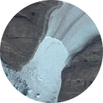
Satellite Imagery
SUB-METER POLAR COVERAGE
United States federally-funded polar researchers with active awards are eligible for high resolution commercial imagery from Maxar via the PGC.
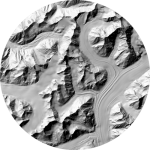
Elevation Models
POLAR TERRAIN DATA
Created from airborne and spaceborne sensors, Digital Elevation Models (DEMs) provide a detailed look at the Earth’s topography. Includes ArcticDEM and REMA products.
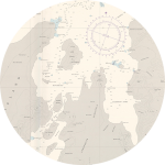
Map Catalog
HISTORICAL AND CONTEMPORARY POLAR MAPS
An archive of polar maps from many organizations available digitally and at no additional cost in many easy-to-use formats.
PGC Guides
Walk through the PGC Guides to learn more how PGC can assist your research project and detailed documentation and workflows for the data and services it provides.
User Services
Interested in receiving support from the PGC? The User Services topic will help walk through the process of getting started!
Commercial Imagery
Want to learn about the imagery PGC provides? The Commercial Imagery topic provides detailed specifications of the satellites and products available!
+ More Guides
PGC provides guides for additional topics that detail other products and services, including elevation models, ArcticDEM, and web applications.
Web Applications
Get the latest
Subscribe to the PGC Newsletter
Join the PGC Community Slack